Miscellaneous Maps, Plans and Books
Below you will find a selection of various items I accumulated over the years including:
1. Philips Cyclist Map of Durham sold
2, Philips Cyclist Map of Yorks SE
3. Philips Cyclist Map of Sussex
4. Map of London commemorating Football Euro 96
5. Philips Popular Map of Hereford
6. Philips Topographical Map of Bristol District - sold
7. W H Smith & Sons Reduced Ordnance map of Dorset
8. Gibson's (1759-79) miniature map of Shropshire - sold
9. School Atlas by John Macturk
10. Street Plan of Torquay with other ephemera
11. Four county maps published by Fullarton including Dorset, Derby, Devon and Durham - sold
12. Biographies of important Victorian publishers
13. Ports and Harbours published by Fullarton
14. Cherry Blossom book mark - very rare item
15. Auction papers for the Luccombe Chine Estate on the Isle of Wight 1891 - sold
16. WWI Christmas Card with small map showing English Channel. Very unusual.
17. Sixteen sets of Liebig trade cards all showing maps - sold
18. Two sets of British cigarette cards with map theme plus some loose cards sold
19. Handkerchief linen map of a Japanese island Hokkaido
20. Copy of the "Kolumbus Atlas" (in German)
21. Facsimile copy of The Mercator Atlas
22. Okehampton and District military map by Forster & Groom
Durham Cyclists' Map by Philips
recently sold
Philip’s Cyclists’ Map of the County of Durham
GEORGE PHILIP & SON
32, Fleet Street London: and Liverpool.
The map is the same sheet as used by Philip to produce the Atlas of the Counties of England from 1862 onwards. However, the map was also reproduced in covers, both as Philips’ New Series of County Maps (typically in red or green covers) and as this edition – Philips’ Cyclists’ Map from circa 1885. The cyclists’ map varied from the County Series in that a variety of information was added specifically for the cyclist. As the cover explains the maps have the main roads distinctly coloured brown, dangerous and other hills are noted with arrows to denote direction, and places where bicycles can be repaired are coded X, and towns in which representatives of the C.T.C. can be found are coded C. In addition hotels for cyclists are noted H (or TH for Temperance Hotels) and even Coffee Taverns are marked (CT).
Although the date of this map is not known, it is possibly one of the earlier cycling maps as the cover has a paper label on boards, whereas later editions had a waterproof printed cover.
Map has manuscript annotations and routes covered by a previous owner as well as a couple of brown spots in the eastern section. Glue has browned the paper where map is pasted to cover.
Philips' maps with this style of cover are comparatively rare.
€20 with free P&P or buy any six priced at €20 for just €100.
Yorks SE Cyclists' map by Philips
Philip’s Cyclists’ Map of the County of Yorkshire, S.E.
GEORGE PHILIP & SON
London & Liverpool.
The map is the same sheet as used by Philip to produce the Atlas of the Counties of England from 1862 onwards. However, the map was also reproduced in covers, both as Philips’ New Series of County Maps (typically in red or green covers) and as this edition – Philips’ Cyclists’ Map from circa 1885. The cyclists’ map varied from the County Series in that a variety of information was added specifically for the cyclist. The maps have the main roads distinctly coloured brown, dangerous and other hills are noted with arrows to denote direction, and places where bicycles can be repaired are coded X, and towns in which representatives of the C.T.C. can be found are coded C. In addition hotels for cyclists are noted H (or TH for Temperance Hotels) and even Coffee Taverns are marked (CT).
Although the date of this map is not known, it is possibly one of the later cycling maps as the cover has a waterproof printed cover, whereas earlier editions had a paper label on boards.
Map has ownership stamp of previous owner as well as the date 14 JUN 1900 printed onto the first inside explanatory panel. Except for signs of wear and staining to the cover (it is 100 years old) the map is in nearly excellent condition.
See website Victorian Maps of Devon entry 141 states 9 and 14 (1860) for details of the Devon map in this series (at http://www.victorian-maps-of-devon.eu/141t.php).
€20 with free postage. Buy six items at €20 for only €100.
Sussex Cyclists' map by Philips
PHILIPS' CYCLISTS' MAP of the county of SUSSEX
Price One Shilling.
Published in London and Liverpool by George Philip & Son.
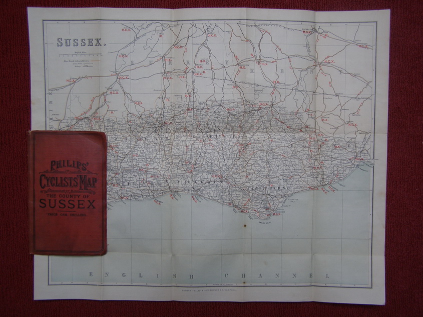
The original maps taken from the same plate were published by George Philip from 1862 and appeared in Philips' Atlas of the Counties of England until the early twentieth century with revisions. Some time around 1885 George Philip began to issue them in the form seen here. Large folding map of the county of Sussex (sheet size 365 x 450 mm) with printed colour denoting sea (pale green) and cycling information (red) laid on linen. Map mainly clean throughout, two spots (in sea area) and red card on linen cover still generally good. Rare state of this map. This seems to be one of the earlier cycling issues with less publishing information on the insides of the covers.
See website Victorian Maps of Devon entry 141 states 9 and 14 (1860) for details of the Devon map in this series:
http://www.victorian-maps-of-devon.eu/141t.php.
€20.00 or buy any six priced at €20 for just €100!
Hereford Popular Map by Philips
Rare map of Hereford.
PHILIPS' POPULAR SERIES OF COUNTY MAPS. HEREFORD
with its railways. Price sixpence.

Published in London by George Philip & Son, 32 Fleet Street & 51 South Castle Street, Liverpool & at all the railway stations.
The original maps taken from the same copper plate were published by Robert Rowe from 1816. Sometime around 1860 George Philip acquired the plates or the last printing batch of these maps (from H G Collins) and began to issue them in the form seen here. Large folding map of the county of Hereford (sheet size 445 x 365 mm) with wash outline colouring on thicker paper. Map clean throughout and green card cover still generally good. Rare state of this map in this style of cover.
See website Printed Maps of Devon entry 81 state 13 (1860) for details of the Devon map in this series (http://www.printed-maps-of-devon.eu/081t.php with an image of the map of Devon from this series).
€20.00 or buy any six at €20 for €100.
Bristol District waterproof map - sold
Bristol District
Philip’s Topographical Map of England and Wales – Cycling Edition
Map and Cover Waterproof – Price Two Shillings - sold
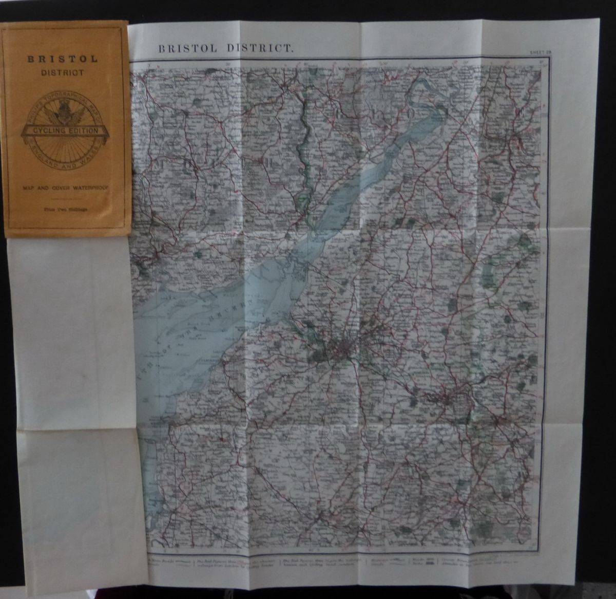
Map Title (from left to right across the top border of the map) is Philip’s Topographical Map of England and Wales (Cycling Edition) – Bristol District – Sheet 28.
Size 380 mm x 480 mm. This constitutes sheet 28 of Ravenstein’s very detailed 33 sheet map of England and Wales completed in 1895. The map has been printed on a special waterproof paper – Pergamon. The map folds neatly into soft orange waterproof covers which also have the logo of the Philip’s Topographical Map of England and Wales. Overall the map and cover is in excellent condition. Quite an unusual map as not many maps were produced on this special paper.
€20 free postage
Euro 96 - London Underground Map
Tube Map issued during Euro 96
Euro 96 Map of London
–
Football Ephemera
–
with Tube map

This is a folding map of London specially produced for the Football European Championships in 1996. The whole sheet opens out to 390 x 230 mm. One side has a map of the centre of London (Kensington Gardens to Holborn and Waterloo stations, map of the London underground network, small map of England showing main road links to London. This side also has information for the visitor on travelling in and around London.
The reverse has information about the (former) Wembley stadium with seating plan. It also has a plan of the matches including groups and kick-off times. There is further information about London Transport Tickets.
The map folds into a small booklet suitable for a shirt pocket (55 x 85 mm) and was produced by London Transport (it bears their logo) with presumably the sponsorship of MasterCard as their logo is prominent and there is a list of MasterCard Welcome Centres.
The map is in almost super condition; there may be some creasing on the outside card cover but map paper is largely clean and no tears or creases.
€5 – free postage.
Dorset by W H Smith & Sons
W H Smith & Son’s Reduced Ordnance Maps for Tourists DORSET
(cover title)
Scale 4 Miles to an Inch
Price One Shilling
Mounted on cloth
London, W H Smith & Son, 186 Strand, and all railway stations
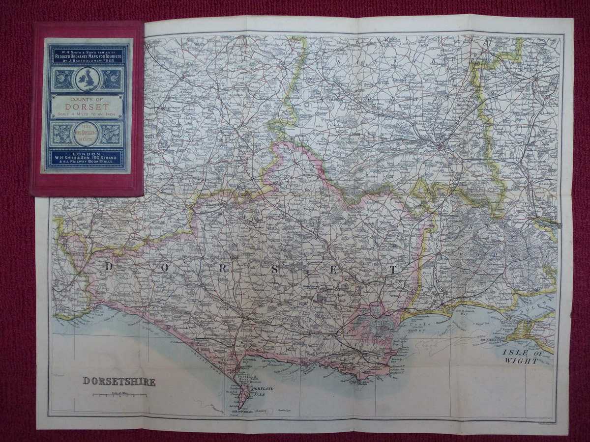
One of W H Smith & Son’s Reduced Ordnance Map series. The section is taken from Bartholomew’s Imperial Map map. See Batten and Bennett, Victorian Maps of Devon (second edition, 2010), entry 150 for Devon in this series. Tentatively dated to 1890 with this type of cover. Map title is Dorset: size is 340 x 460 mm. Folding into stiff (faded) red cloth covers with decorative paper label. Map clean, cover a little grubby.
See website Victorian Maps of Devon entry 150 for details of the Devon map in this series at
http://www.victorian-maps-of-devon.eu/150t.php.
€20.00 or buy any six at €20 for €100.
Victorian School Atlas
Physical Geography
By John Macturk; one of the Collins' Elementary Science Series; William Collins, Sons, & Company; 1873.

Green embossed cloth boards with tidy appearance to front cover, gilt title on spine but water staining over half of the back cover. Inside endpapers are browned due to quality of paper used and there are spots on outside endpapers. Name of a previous owner - Iris Bendall – on front endpaper; pencil name, address and small sketch on half-title. Tidy little school geography book (170 x 115 mm) of 156 pages with index. Five small full-colour maps by John Bartholomew, leading map manufacturers at the end of the nineteenth century, one double-page (map of the world).
€20.00 or buy any six items at €20 for €100.
Very Unusual Cherry Blossom Book Mark
CHERRY BLOSSOM BOOKMARK
advertising card with Balloon motif
with Calendar for 1890 and 1891
possibly published and issued in France
French and English text.
This is a bookmark advertising Cherry Blossom Shoe Polish with an illustration of a balloon ascent on the front and a calendar for the years 1890 and 1891 on the reverse. Size 115 mm (h) x 67mm (w).
The book mark is in excellent condition and has clearly never been used as the perforated "V" centrally (to clip over the current page) is still in pristine condition. It does have a slight crease across the top right corner. The illustration has the text:
LE FIGARO, 7-9-89.
L'ascension du ballon-flacon
"le Cherry Blossom" a
parfaitement réussi. Parti
de Grenelle , après avoir atteint
2,800 mètres d'altitude
il est tombé près
Vélisy, en Seine-et-Oise.
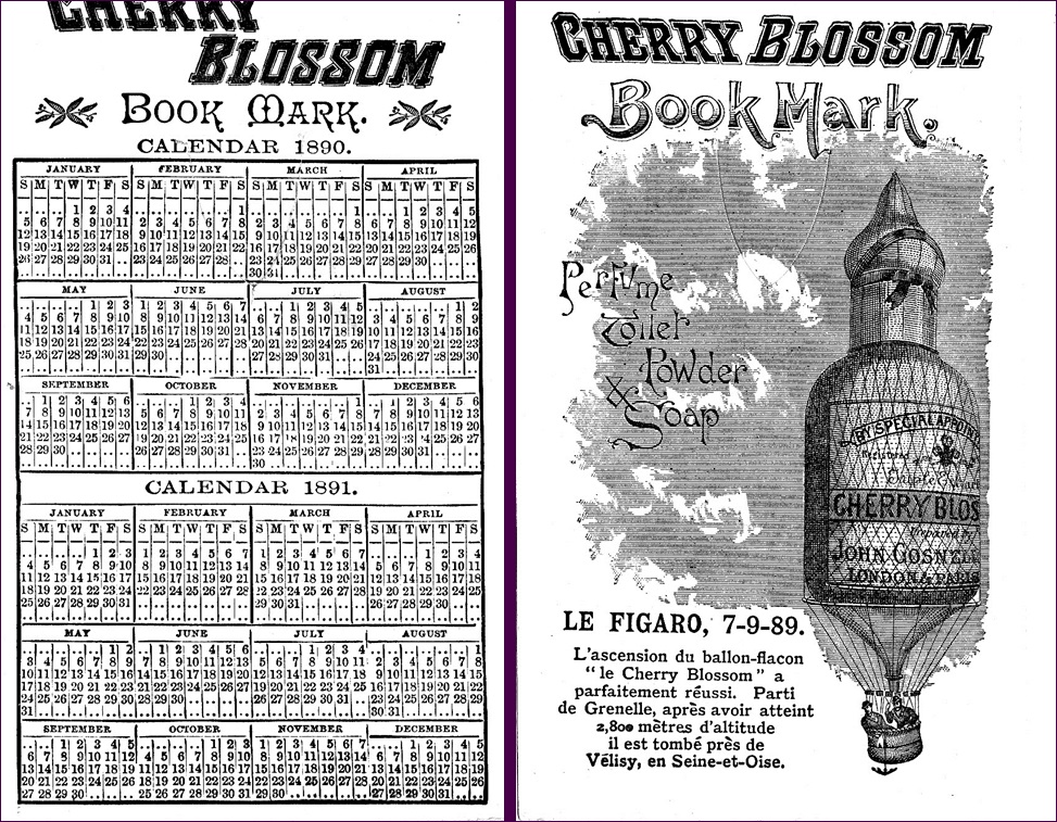
Text on back is in English with months in English for both years.
€20 or buy any six items at €20 for only €100
Victorian Publishers - set of biographies
Six books on Victorian Printers and Publishers
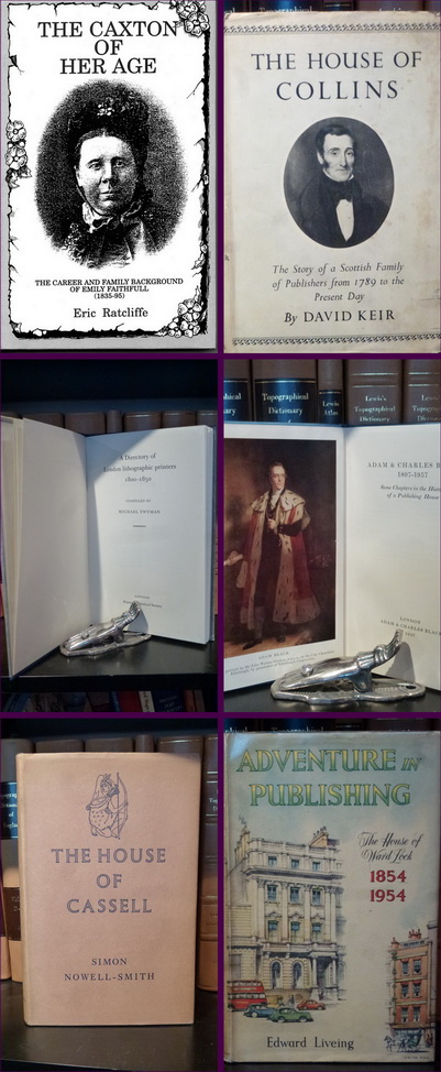
The Caxton of Her Age
The Career and Family Background of Emily Faithfull by Eric Ratcliffe.
Story of an early feminist who began her own printing business in London. Original price in 1993 was £6:95. 96 pages, Hardback with printed covers, black and white pictures embedded in text. Good.
Emily Faithfull was born in 1835 and established the Victoria Press in 1860 and subsequently published a number of feminist magazines and newspapers. She was a popular speaker, touring America three times and officially received a pension from the Civil List. She died in 1895.
The House of Collins by David Keir
Hardback with dustjacket (rough edges and grubby). Collins, London, 1952. 303 pages with index, 13 illustrtations (black and white) interspersed.
Written by Keir on occasion of the company's 100th centenary of the death of the founder of the Collins publishing house, William Collins. Somewhat shaken and grubby but a useful work for anyone doing research on Victorian publishers.
A Directory of London lithographic printers. 1800 – 1850.
By Michael Twyman.
1976. The Printing Historical Society, London. 55 pages with map s incl. one fold-out, of locations of London lithographers during this period. Blue cloth, gilt spine title, in original tissue dustwrap paper. A reference source book on lithographic trade in the first half of the nineteenth century.
Adam & Charles Black 1807-1957.
Black. 1957. 115 pages including index. Blue cloth covers with title label. 6 illustrations (four in colour).
Written anonymously on behalf of the Black company on their 150th anniversary. A useful work for anyone doing research on Victorian publishers.
The House of Cassell by Simon Nowell-Smith.
Cassell & Company, 1958. 299 pages including index. Blue cloth covers with gilt spine title, still with dustcover (fair but fading at spine).Numerous illustrations in text (b/w only).
Written on behalf of Cassell and company on their 110th anniversary. A useful work for anyone doing research on Victorian publishers.
Adventure in Publishing by Edward Liveing
Hardback with dustjacket (with protective plastic jacket). Ward, Lock& Co, London, 1954. 108 pages with index, 17 illustrations (black and white) interspersed.
Written by Liveing on occasion of the company's 100th centenary of the founding of the publishing house, Ward, Lock & Co. Discreet embossed ownership stamp on inside endpaper. A little discolouration to spine and page edges but a useful work for anyone doing research on Victorian publishers.
€50.00 but ask for more information (and I will check what other books of this type I can include in the offer).
This is a very useful set of biographies for those interested in publishing during the time of Victoria. If the purchaser is a library or similar institute I have other guides on Victorian publishers which I am prepared to add at no added cost (but possible extra postage depending on quantity).
Plan of Torquay - free to a good home!
Indexed Street Plan of Torquay with places of interest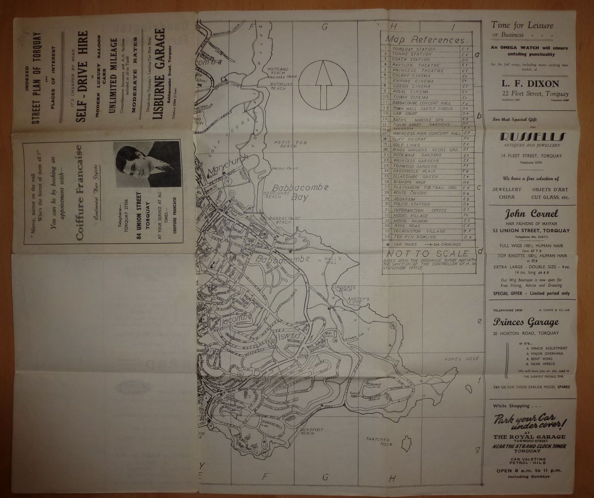
Map of Torquay from the 1960s. Simple plan of Torquay with roads named and places of interest marked and numbered with a key. Lots of adverts to right and left and some on outside covers. Full street index on reverse. Sheet is approx 480 x 720 mm (h x w) and map itself 480 x 560 mm. Printed on normal quality paper with no card reinforcement, so has usual minor tears at fold ends and four minor tears where folds meet not affecting overall appearance.
Free – add it to any other purchase from my listing.
Plans of Ports and Harbours pub. Fullarton
Map of English Ports and Harbours.
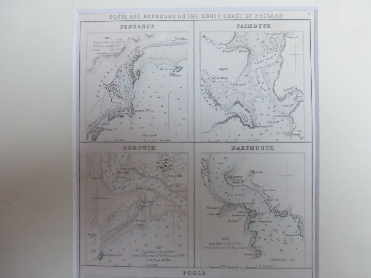
PORTS AND HARBOURS OF THE SOUTH COAST OF ENGLAND
Penzance, Falmouth, Exmouth, Dartmouth and Poole harbours on one sheet. In passe-partout.
Published 1840s by A Fullarton & Co., Edinburgh, Dublin and London.
Size 225 x 140 mm. Nice clean example. Each port has detail of sandbanks and depths etc. Pale blue wash colouring for waterways.
Archibald Fullarton (fl.1834-70) founded the firm A Fullarton and Co, publishers and engravers of Glasgow 1833-40, of London, Edinburgh and Glasgow 1840-43, and of London, Edinburgh and Dublin, from 1845. Fullarton was responsible for many works including the Parliamentary Gazetteer (various editions between 1833 and 1849), Rev. J M Wilson’s Imperial Gazetteer of Scotland and John Bartholomew’s influential Imperial Map.
€20 or buy any six maps priced at €20 for only €100.
WW1 Christmas Card by Devambez Paris for the Royal Navy Division
World War One Christmas Card – 1917 – Devambez, Paris – Royal Navy
Lovely Christmas Card possibly sent from the French trenches during the Christmas of 1917.
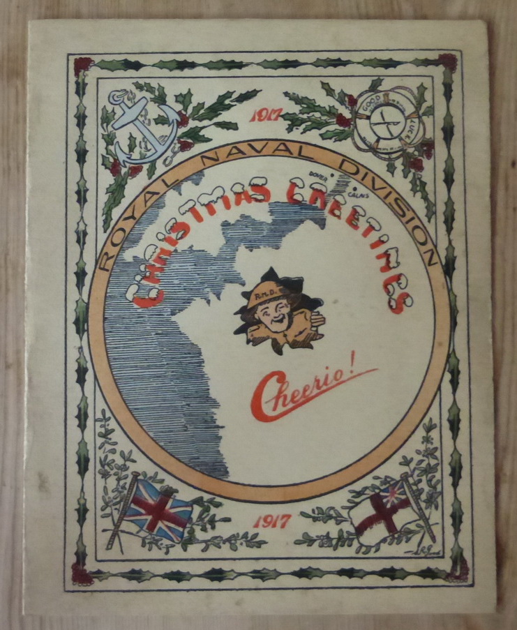
The card was printed by Devambez at 63, Passage des Panoramas in Paris. The card has a picture of a British troop (R.N.D.) in the centre of a map of southwest Britain and north-eastern France, the whole within a circle with Royal Naval Division. Surrounding the whole is a frame with holly decorations and significant emblems such as anchor, life belt and flags of the navy and merchant marine.
The printed text inside is: BEST WISHES FOR A MERRY XMAS AND HAPPY NEW YEAR FROM ... and has been signed George – to Grace – with Love (in pencil). On the facing page is a delightful coloured illustration of a British soldier chasing one German with his bayonet while stepping on the face of a second. The title is "A little "Salt" on his Tail.” This looks like it was printed in the original card and the illustration is signed and dated (difficult to read, possibly H Heslentz).
Card generally in good condition although slightly grubby around edges.
€20.00 or buy any six priced €20 for just €100
Okehampton and District Military map
WHITEHALL SERIES of MILITARY MAPS
OKEHAMPTON and DISTRICT
Published by Forster Groom & Co., Ltd.
Folding map showing the artillery ranges in the vicinity of Okehampton.
Folding map in two blue card covers (front and back – no spine used) with publisher’s details: Forster Groom & Co., Ltd., Naval and Military Publishers, 15, Charing Cross (Near Whitehall), S.W. (Next door to Messrs. Cox & Co.).
This map is printed on paper and folds out between its blue card top and bottom covers to 380 x 330 mm folding to 180 x 115 mm. The map is generally sound. Scale 2 inches to one mile. No apparent tears, slight browning overall. The artillery range and the camp are shown in red. Map has slightly different title: New Military Map of Okehampton & District (Artillery Ranges) Corrected from the Ordnance Survey with publisher’s details and is dated 1910.
Very unusual - €30 with free postage
Two British Cigarette Card Sets plus loose cards and magazines
English Cigarette Cards – Two sets with maps plus a variety of others
Set 1. Counties of Great Britain – set of 25 coloured cards showing one county with a typical occupation and description of county on reverse
Set 2. Products of the World – set of 25 cards with a country depicted (map) and a typical product / occupation and description on back. Believed to be from 1909.
Plus
Set of Flags of the League of Nations issued by John Player and Sons (50 cards 1928); Struggle for Existence issued by John Player and Sons (25 cards); Railway Equipment issued by W D and H O Wills (50 cards); Ceylon Tea issued by Ceylon Tea Centre (Series A 25 cards); plus 10 odd map cards from different sets.
Plus Cigarette Card News And Trade Card Chronicle
Various numbers from 1997/8
Thirteen magazines each approx. 28 pages in coloured covers with various articles on cards for collectors.
August 1997 to January to September 1998 (lacks March).
€50 free postage.Send for more images / information.
Handkerchief map of Hokkaido Island, Japan
Map of Hokkaido Island, Japan, on linen
Lovely colourful map of the island showing relief and infrastructure with inset plan of one of the major cities – probably Sapporo. Complete map printed on linen and in Japanese. 345 x 420 mm. Reverse blank. Still in almost perfect mint condition. Lovely item.
€20. free postage.
Kolumbus Atlas (Deutsch) - selection of early maps and portolans
DER KOLUMBUS ATLAS
Facsimile Landkarten/Atlas von Kenneth Nebenzahl
Karten aus der Frühzeit der Entdeckungen
Verlag: Westermann (Braunschweig) 1990.
37cm. 166 Seiten. Gewebe in Schuber. Sehr gutes Exemplar – wie neu. 2.5 Kg. ISBN 3-07-50-9276-2
Text: Deutsch
Übersetzung aus dem Amerikanischen Jobst-Christian Rojahn. 166 Seiten mit zahlreichen Abb. und 50 Karten-Tafeln, goldgeprägter Leinen-Einband (blau) im illustriertem Schuber, neuwertig und sehr schön erhalten. 38,5 x 29 cm, ca. 2,5 kg schwer!. 1. deutsche Auflage.
€20 Germany only. Contact me for P&P to other countries.
Facsimile Atlas - The Mercator Atlas of Europe (English)
The Mercator Atlas of Europe:
Facsimile of the Maps by Gerardus Mercator
contained in the Atlas of Europe,
circa 1570-1572, edited by Marcel Watelet
Slipcase 11.25 x 16.375 inches
ISBN 0-9659735-7-3
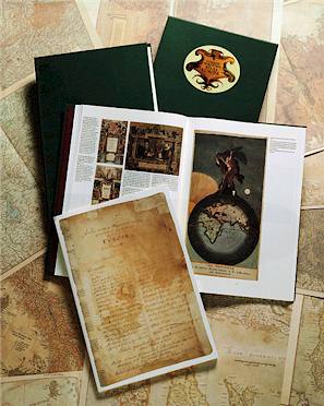
The Mercator Atlas of Europe from Walking Tree Press represents a remarkable publishing achievement, combining the best of historical and cartographic scholarship with modern printing technology to produce a unique and elegant set of seventeen facsimile maps by one of history's greatest mapmakers. Completing the set and complementing the map facsimiles, the accompanying book contains essays contributed by an international team of distinguished map scholars.
 With more than 100 original-color illustrations drawn from collections throughout Europe and the United States, the companion book places Mercator's first-known atlas in historical perspective and offers the reader a unique glimpse into the geography and cartography of sixteenth-century Europe.
The Mercator Atlas of Europe is truly a "feast for the eyes and mind, combining the high art of maps with first-rate scholarly pursuits—a marvelous union that Mercator would surely endorse." (Mercator's World®, Nov/Dec 1997)
For full description visit the Walking Tree website at http://www.walkingtree.com/MercatorAtlas/
This example almost new with almost no blemishes. Still in original slipcase which is also in virtually mint condition. Currently on sale new at $245.
€45. German addresses only. Please contact me for P&P to other destinations as this book is quite heavy.